
Weather Warnings in South Africa: Stay Alert & Stay Safe
South Africa is facing significant weather warnings, with multiple provinces on alert due to a cut-off low pressure system. The South African Weather Service (SAWS) has issued warnings of disruptive rain, hail, strong winds and severe thunderstorms that may cause flooding, damage to infrastructure and danger to life.
SIMILAR: Why NSFAS Remains an Essential Lifeline for South African Students
Table of Contents
Currently 60° · Cloudy
| Weather Detail | Status |
|---|---|
| Current Temperature | 60°F (15°C) |
| Condition | Cloudy |
| Humidity | Moderate |
| Wind Status | Light to Moderate Winds |
| Visibility | Good |
| Cloud Cover | Thick, widespread cloud layer |
| Rain Probability | Possible later in the day |
| Storm Risk | Low now, may increase later |
| Feels Like | Cool and slightly humid |
| General Outlook | Calm now; could shift to storms |
What’s Happening & Where
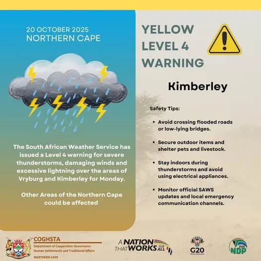
A powerful weather system is currently affecting the country. SAWS says heavy rainfall and thunderstorms will hit areas including the KwaZulu‑Natal (KZN) province starting Saturday and continue into Monday, and will then spread to the Free State, Gauteng, Limpopo, Mpumalanga and the Northern Cape. IOL+1
In KZN specifically, warnings range from Level 2 to Level 4, depending on the municipality, indicating moderate to high risk of severe impact.
What You Need to Know: Key Impacts
According to SAWS, the expected impacts include:
- Heavy downpours and severe thunderstorms that may cause localised flooding of roads, low-lying areas and bridges.
- Strong, damaging winds and large amounts of hail in some regions.
- Risk of damage to infrastructure, power outages, blocked roads and danger to life from fast-flowing water.
Who Should Be Especially Careful?
Residents, commuters and businesses in the following areas should monitor conditions closely:
- Western parts of Free State, North West, and north-eastern Northern Cape (orange level 5 warnings).
- Central and western KZN (yellow level 4) where risk is higher.
- Gauteng, southern Mpumalanga, Limpopo and surrounding interior regions (yellow level 2) as the system moves in.
What to Do to Prepare
- Keep up to date with local SAWS warnings and alerts via official channels.
- Avoid travel through low-lying or flood-prone areas during heavy rain. Bridges and minor roads are especially at risk.
- Secure loose items outdoors and prepare for possible power outages or hail damage.
- Families and businesses in vulnerable areas should plan for possible evacuation or sheltering.
- Children, the elderly and people with mobility issues should not be exposed to outdoor risks when thunderstorms hit.
Why This Matters
These weather warnings highlight how swiftly conditions can deteriorate. Past events, such as the devastating KZN floods of April 2022, show how life-threatening heavy rain and storm systems can become. With infrastructure stretched and climate events becoming more intense, preparedness is more important than ever.
Conclusion
Weather warnings in South Africa are currently elevated — especially in provinces like KwaZulu-Natal, Free State and Gauteng — due to heavy rain, strong winds, hail and thunderstorms. Understanding the risk, staying informed, and acting early can make all the difference. With the right preparation, you can stay safe and reduce the impact of disruptive weather.
Check more E NEWS articles;
- Marco Hall Net Worth 2023
- How do you show true love?
- Aaron Krause Net Worth 2023
- Richard Hilton Net Worth 2023
- Michael Rapaport Net Worth 2023
- Ratiba ya Mitihani ya Darasa la Nne 2025
- Matokeo ya kidato cha sita 2025 Haya Hapa
- Ratiba ya Mitihani ya Kidato cha Pili (CSEE) 2025
- Ratiba ya Mitihani ya Kidato cha Nne (CSEE) 2025